Exploring the Alpine Trails of the Dolomites
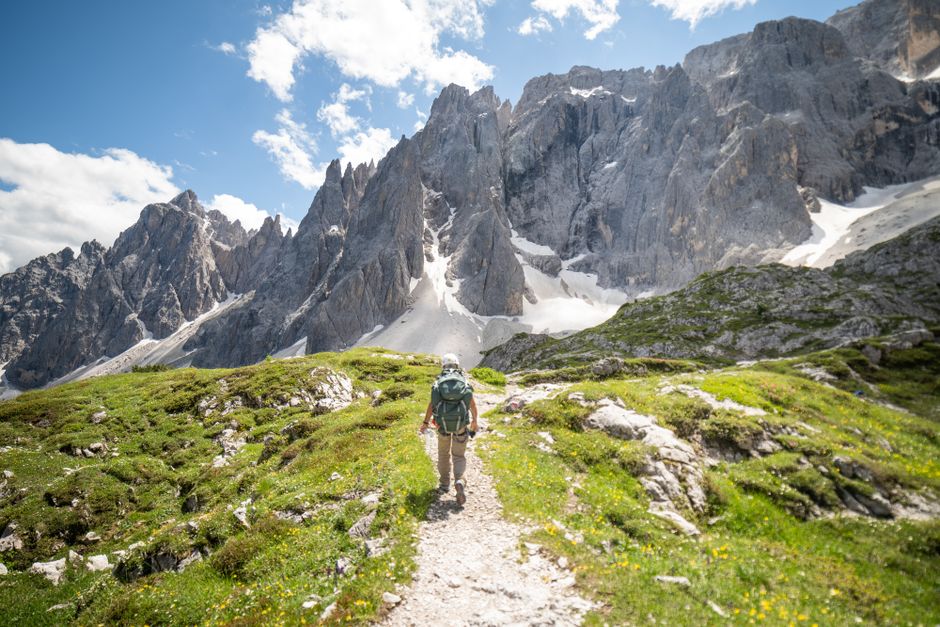
The Dolomites in northeastern Italy are recognized as a UNESCO World Heritage site, known for their dramatic limestone peaks and high-altitude meadows. For hikers, the region offers a network of well-marked trails that pass through diverse landscapes, from rugged mountain passes to serene alpine lakes. This article provides an overview of three scenic hiking routes that highlight the distinctive geology and beauty of the Dolomites, each presenting its own character and level of challenge.
The trails selected range in difficulty and length, allowing hikers with different experience levels to explore the region. While some routes involve steep ascents and exposed ridges, others follow gentler paths around iconic peaks. Regardless of the chosen trail, preparation and awareness of mountain conditions remain important factors for a safe and enjoyable experience.
The Iconic Tre Cime di Lavaredo Circuit
Often considered the most recognizable landmark in the Dolomites, the Tre Cime di Lavaredo circuit is a classic loop trail that circles the three towering peaks. The route begins at Rifugio Auronzo, which is accessible by car or shuttle bus from the town of Misurina. From there, hikers follow a well-maintained path that gradually ascends towards the base of the rocky spires. The total distance is approximately 10 kilometers with a moderate elevation gain of around 350 meters, making it suitable for most hikers with a reasonable fitness level.
Along the way, several rifugi provide opportunities to rest and enjoy local cuisine. The trail offers sweeping views of the surrounding mountains, including the Cristallo group and the Paternkofel. In clear weather, the contrast between the pale limestone and the deep blue sky is particularly striking. Many hikers choose to complete the loop in a clockwise direction to take advantage of the best lighting for photographs. The entire circuit typically takes between three and four hours, though extended stops for meals or side excursions can lengthen the day.
One notable feature of this trail is its exposure in certain sections. While the path is generally wide and well-graded, there are a few narrow segments that require attention. Hikers should be prepared for sudden weather changes, as clouds and wind can move in quickly even in summer. Carrying a windproof jacket and sufficient water is advisable, as there is limited shade along the route.
The Seceda Ridgeline Hike
The Seceda ridgeline, located in the Gardena Valley, is famous for its sawtooth shape and its stark, almost lunar appearance. The hike typically starts either from the town of Ortisei, using a cable car to reach the high plateau, or from the nearby town of Santa Cristina. Once at the top, the trail runs along the ridgeline, offering panoramic views of the Odle and Geisler groups. The main loop is about eight kilometers long and involves a moderate amount of elevation gain, mostly concentrated on the approach to the ridge.
Hikers on the Seceda trail move through a mix of grassy alpine meadows and rocky terrain. The ridge itself is a narrow path that, on clear days, reveals the valleys on both sides. This trail is particularly popular for its dramatic perspective on the surrounding mountains, and many visitors find the visual contrast between the vertical rock spires and the green slopes memorable. The hike can be extended by connecting to the path towards the Puez-Odle Nature Park or by descending through the meadows to the town of Selva.
Because the route is exposed to the sun for most of the day, sun protection and adequate hydration are important considerations. The cable car operation schedule also influences the timing of the hike, as the last descent typically occurs in the late afternoon. Hikers who prefer a quieter experience may consider starting early in the morning, when the light is soft and the crowds are smaller. The trail is well-marked with standard CAI signage, but a map or navigation app can be useful for identifying connecting paths.
The Lago di Braies to Croda da Lago Trail
The trail from Lago di Braies to Croda da Lago begins at one of the most photographed lakes in the Dolomites. The emerald-green waters of Lago di Braies attract many visitors, but the hiking route quickly leaves the busy lakeshore behind and ascends into quieter terrain. The destination is Lago di Federa, a smaller lake set beneath the rocky face of Croda da Lago. The round-trip distance is roughly ten kilometers, with an elevation gain of about 500 meters, placing it in the moderate category.
The path winds through a forest of larch and pine before opening up to alpine meadows. Sections of the trail are rocky and require careful footing, especially after rain. As hikers gain elevation, the view of the Braies valley expands, and the surrounding peaks become more prominent. Lago di Federa itself is a shallow lake surrounded by grassy banks, where a rifugio offers simple meals and refreshments. The tranquillity of this spot, combined with the reflection of Croda da Lago in the water, makes it a popular rest point.
Hikers should note that the trail can be muddy in the early season, and some stream crossings may require careful navigation. The return is along the same route, allowing for a different perspective in the afternoon light. This trail is less crowded than the Tre Cime circuit, particularly on weekdays, and provides a more secluded experience. As with all high-altitude hikes, checking the weather forecast before starting and adjusting plans accordingly is a standard practice.
Understanding Trail Conditions and Safety
The Dolomites are characterized by rapidly changing weather patterns, and trail conditions can vary significantly from day to day. Elevation plays a key role in these changes, with temperatures dropping noticeably above 2,000 meters. Afternoon thunderstorms are common during the summer months, often developing quickly in the late morning. Hikers typically plan to start early in the day and aim to be below exposed ridges by midday to reduce the risk of encountering lightning or heavy rain.
Trail markings follow the CAI (Italian Alpine Club) system, with red and white stripes indicating the main path and painted circles or arrows at junctions. Many routes also feature signs with estimated walking times. Despite these markings, navigation in fog or cloud cover can become difficult, and carrying a physical map or a GPS device is a common precaution. The rocky terrain can be slippery, especially on descents, and sturdy footwear with good grip is essential.
Altitude may affect hikers differently, and symptoms of acute mountain sickness can occur even at moderate elevations. Gradual ascent, proper hydration, and adequate rest are general approaches that many hikers use to mitigate these effects. First aid kits and communication devices are often recommended, as mobile phone coverage is not consistent in all valleys. The availability of mountain rescue services varies by area, and hikers are generally responsible for their own safety planning.
Choosing the Right Time and Logistics
The typical hiking season in the Dolomites runs from mid-June to late September, when most trails are free of snow and the rifugi are open. July and August see the highest number of visitors, which can affect trail congestion and accommodation availability. For those seeking quieter conditions, late June or early September offer pleasant weather and fewer hikers. Snow can linger on some high-altitude passes well into June, so checking current conditions with local tourist offices or rifugi is a common step before setting out.
Access to trailheads often involves a combination of driving and cable car rides. Parking near popular starts like Rifugio Auronzo or Lago di Braies can fill quickly, and shuttle services operate during peak season. Public transport, including buses run by SAD, connects major towns and valleys, providing an alternative to car use. Accommodation options range from mountain huts (rifugi) to hotels in the valleys, and advance booking is advisable in summer months.
Hikers new to the region may find it helpful to consider guided packages or self-guided itineraries offered by specialized operators. For example, organizations such as Alpine Routes provide logistical support and pre-planned routes for those who prefer a structured experience. While independent planning is certainly possible, these services can assist with transportation, accommodation, and route selection, allowing hikers to focus on the trail itself. Regardless of the approach taken, the key to a rewarding Dolomites hiking experience lies in thorough preparation and a flexible mindset.